


Use the below JOIN button to receive exclusive access to many more steamy hot Fetish, B&D high resolution photos.
189 Photos
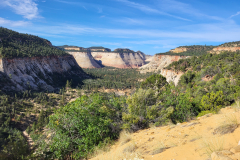
This was my fourth day hiking about 10 miles a day. I started the hike early because rain was coming sometime between Noon and 5 PM. I wanted to be out of the canyons before it started raining hard. 7 am I was out the door of my lodge. I walked along the rim and down the Tower Bridge Trailhead. I found it magnificent as the trail wove around the canyons. It does go down, up, down and up again to reach the Rim trail. The Rim Trail between the Fairyland Trailhead and the Tower Bridge Trailhead is NOT flat. One can drive and park a few feet from the Fairyland Trailhead and do this hike in the opposite direction. I do not know which is easier. I loved the experience and found this trail a wonderful finale to my four days of hiking.
38 Photos
I arrived to Bryce Canyon National Park early afternoon and checked into the lodge. Soon after I was out and walking the rim to the Wall Street trailhead down into The Queen's Garden. This is a moderate hike, as going down into the canyon is steep but easy down the switch back and stairs. However, what you walk down into, you must climb out of.
22 Photos
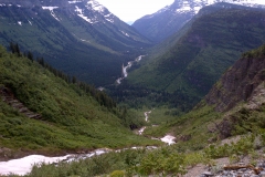
This is a very easy trail with guard rails almost the whole climb. It winds out to overlook the Valley just before the tunnel. It isn't very long and gives great views.
18 Photos
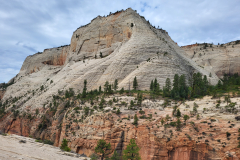
The Watchman mountain is the first mountain on the right as you drive into Zion National Park. The trailhead is pretty close to the Pa'rus trailhead. The trail is pretty easy, as it is marked and stepped out well. It does have some elevation to navigate as you climb. This is a great morning trail in the shade. I loved the loop trail on top.
22 Photos
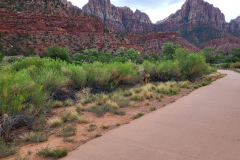
This trail is on the floor of the Zion Valley. Dogs, wheelchairs, bikes are welcome on this trail which connects to the campgrounds just above the Welcome Center. It is flat, yet, it gives a valuable perspective of the Valley.
5 Photos
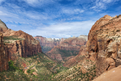
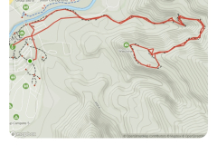
I started from The Zion Lodge on The Grotto Trail and crossed the street to the trailhead for The West Rim Trail. The West Rim Trail to Scout Lookout is the popular trail to Angel's Landing. One now needs a permit to go in that direction. The West Rim Trail continues another 20 miles in the opposite direction. I hiked another miles or so up before turning around.
21 Photos
This trail is the first street north as you enter zion on the East gate. It is an abandoned horse or mule trail. You will see a perfectly good corral with a clean water trough. The trail is mostly covered in fine sand, red or white depending on the sandstone you are traveling through. I am sure the hooved animals loved it. You will sink into it. The scenery is vastly different than the Zion Valley, as it reminded me on being on the eastside of California. I only saw two other folks on this trail all day, and that was as I was leaving, they were coming up, and we past about a mile from the trailhead.
30 Photos

88 Photos
66 Photos
Monday Morning, I walked around The Village and shopped for coffee cups before heading home. I love being at the Grand Canyon.
17 Photos
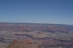
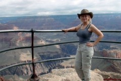
I walked around the South Rim at The Village in the afternoon then took The Pink Jeep Sunset Grand Canyon Tour. This tour is the total East Rim Drive experience. It stops at the prominent vistas, some more remote as we went east from Grand Canyon Village to the Desert View Watchtower. Our Pink Jeep Tour guide showed us the indigenous fauna, flora and provide captivating geological and human history. The Desert View Watchtower has murals depicting scenes of Hopi culture and four flights of stairs to climb to the top. Then you may peer down thousands of feet and witness the mighty Colorado River where it curves and heads to the west. On a clear day you can see over 100 miles!
116 Photos
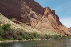
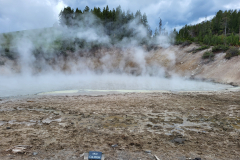
This Rafting trip was 15 miles of scenic wonder traveling through the Inner Gorge of Marble Canyon. Towering cliffs, cool Emerald Green water, the smell of the Colorado, and the sound of a Great Blue Heron and California Condor.
77 Photos
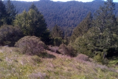
On February 22, 2013 I had the opportunity to hike around Muir Woods for 6 hours with my brother. Here are some captures of the beauty we saw.
44 Photos
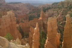
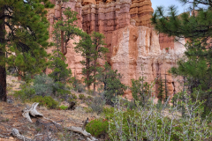
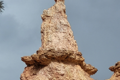
July 29, 2011 i set out of Las Vegas on a Road Trip thru Zion National park, Dixie National Park and on to Bryce canyon National Park. i stayed at the Bryce Canyon Lodge in Bryce Canyon National Park Friday night, Saturday and Sunday. Saturday i hiked the Fairyland Loop (8 miles) down into the bottom of Bryce Canyon, wandering among the Hoodoo’s. Sunday i trekked down Sunrise Point thru Thor’s Hammer, up to Two Bridges, along the Queen’s Garden path, to the Queen Victoria hoodoo, and up the path to Sunrise Point. The path from Sunrise Point to Sunset Point is serene,impressive, and awesome, the the forest on one’s left, and the “forever and ever” views out over the rim gazing at the vast Bryce Canyon before one. enjoy!
90 Photos
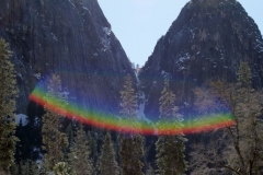
i took my family to Yosemite Valley in early spring of 2011. i was thinking green meadows and new spring flowers. It snowed this year all the way through to June it turned out (snow storm blowing thru, then clear days). We were the first people in the valley after it was evacuated for a week. i was told there were maybe 100 people in the whole valley when we arrived there. The trails were open, they were simply covered in snow by several feet (at least) deep. i will not be posting any images of my family here. We had a marvelous time, and you will have to take my word for it. How could anyone not have the weekend of their dreams in such beauty?
118 Photos
On 21 August my grandchildren had a Pirate Birthday Party. Madoc and i dressed as pirates and played with all the children. It\'s on u-tube somewhere\'s on my daughter\'s channel. Then we were off to explore Yosemite National Park. First a view stop over Mono Lake was irresistible. Then on down the 395 to the east entrance to Yosemite National Park. We traveled in on Tioga Road, as it was late August and the road is open.
First on our list was The Giant Sequoia Grove
Tuolumne Grove of Giant Sequoias
Tuolumne Grove Trail
Distance: 2.5 miles (4 km) round trip
Elevation at trailhead: 6,200 feet (1,860 meters)
Elevation Gain: 400 feet (120 meters) elevation loss to the grove.
Why visit the Tuolumne Grove? If you\'re a dessert-first kind of person, the Tuolumne Grove trail was made for you: the entire trip to the grove is downhill. Oh, and the grove itself contains a couple dozen mature Giant Sequoias, including one you can walk through (although it\'s dead - but then, you would be too).
Hiking Time: 1.5 - 2.5 hours
Second stop:
Tenaya Lake
Distance: 2.5 miles (4 km) loop around the lake
Elevation at trailhead: 8,150 feet (2,480 meters)
Elevation Gain: none
Hiking Time: 1 - 2 hours
Why visit Tenaya Lake? A day on the sand at the east end of Tenaya Lake, where you can de=stress with a cadre of fellow sun worshipers on most summer days. If not a sun worshiper, sitting on the north side looking out over the crystal clear lake doesn\'t suck too much - ever. Then you can head to the west end of the lake, where the view back across the lake to the granite promontories that surround it is about as sure a postcard shot as you\'ll ever find.
The next day we were back bright and early, on Sunday to explore.
First stop:
Tuolumne Meadows
Distance: 2 miles (3.2 km) more or less; it depends on how much wandering you want to do
Elevation at trailhead: 8,500 feet (2,550 meters)
Elevation Gain: none to speak of
Why visit Tuolumne Meadows? There\'s just something about a meadow that\'s good for your peace of mind. And this is one of the great meadows, nearly two miles (3.2 km) long, with a river (the Tuolumne) winding through it and a variety of picturesque granite peaks and domes surrounding it.
Second stop:
North Dome
Distance: 8.8 miles (14.2 km) round trip
Elevation at trailhead: 8,100 feet (2,470 meters)
North Dome Elevation: 7,540 feet (2,300 meters)
Hiking Time: 4 - 6 hours
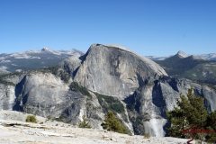
Why Hike to North Dome? You haven\'t really seen Half Dome (figuratively, at least) until you\'ve stood on North Dome and looked across Yosemite Valley at it. It\'s an incredible closeup view. North Dome also offers an unsurpassed view of Clouds Rest, a peak that tends to get obscured by scene-stealing Half Dome when you\'re sightseeing from Glacier Point or Yosemite Valley.
These were two fantastic, serene days, the stuff that feeds your soul and lifts your spirit. i highly recommend these easy, yet supreme hiking outings.
115 Photos
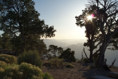
Dale from www.seriousbondage.com, and i traded off driving duty taking my car from Los Angeles, California to The Grand canyon Nation Park arriving around 2 pm on Friday, 6 August 2010. The Grand Canyon is vast, majestic, serene, the light hitting the rock ever-changing to captivate your eye. It\'s magical. Friday afternoon, Dale and i walked the South Rim from El Tovar about an hour, then headed back. i went out just before dinner for some sunset shots, then walked around the lodges, and was delighted to see the deer (one doe had two fawns following her). Up early on Saturday morning, Dale and i planned to hike down into the canyon on Bright Angel Trail. It was sprinkling. It didn\'t blow past, and instead rained heavily all day. Still we made it down 3.5 miles, with the mules passing us 3 times. Great looking strong animals. The colors were incredible as i hiked down, trying my best not step in the huge puddles that were deeper than my hiking boots. It became a progressively muddier trail. i was very glad i hiked down into the canyon though because i got a perspective how big it is. 3.5 miles only took us an insignificant amount down into the canyon. It was the first time i realized just how very far away everything i was looking at was. Sunday the weather was cool but the shower storm held away from the south rim. Dale and i hiked 8 miles west out to Hermits Point and then back to El Tovar, then east out to the end of the trail on the South Rim (about 4 miles). Monday morning, Dale and i walked along the roads and paths in the residence, finding the hospitality suite of the mules, and a peaceful walk through the woodlands. It is a spectacular place, simply breath taking and beautiful to see, touch , smell. i highly recommend it.
102 Photos
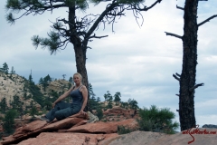
i rented a mid-size car for $15.00 a day from Hertz thru priceline.com. Madoc flew into the Las Vegas airport Friday evening where i picked him up and drove to the Zion Lodge in Zion National Park. It was an easy drive, even in the dark. Saturday morning we hiked the Lower Emerald Pool (1.2 miles - Easy with minor drop-offs. Paved trail takes you to lower pool and small waterfalls.) and Middle Emerald Pool (2.0 miles - Moderate with steep drop-offs. Loop trail to lower and middle pools.), plus the North Fork Trail but returning back to Emerald Pools and returning to Zion Lodge. At twilight we took off to Weeping Rock (.5 miles - Short, but steep with minor drop-offs. Paved trail ends at a rock alcove with dripping springs. Hanging gardens of wildflowers decorate the walls in spring and summer. Trailside exhibits.), The Temple of Sinawava (2.0 miles - Riverside Walk - Easy. Minor drop-offs. Paved trail follows the Virgin River along the bottom of a narrow canyon. Hanging gardens of wildflowers in spring and summer. Trailside exhibits.), and The Narrows. Sunday morning we took off for Angels Landing (5 miles - Strenuous with steep drop-offs and narrow trail. Not for anyone fearful of heights. Ends at summit high above Zion Canyon. Last 0.5 mi (0.8 km) follows a steep, narrow ridge; chains have been added.). Zion National Park is located along the edge of a region known as the Colorado Plateau. The rock layers have been uplifted, tilted, and eroded, forming a feature called the Grand Staircase, a series of colorful cliffs stretching between Bryce Canyon and the Grand Canyon. The bottom layer of rock at Bryce Canyon is the top layer at Zion, and the bottom layer at Zion is the top layer at the Grand Canyon. Just before we were to cross The Arch, it started to down pour. Since we were now looking at wind, rain and very slippery rock, we were good with how far we had hiked and turned back. The late afternoon was spent in Springdale looking about. That evening we went to the lodge lawn and did some Star Gazing in the vast darkness which made the stars shine clearly. I found Zion Canyon indeed serene and peaceful. The beauty and natural energy fed my soul. It was incredible.
69 Photos